
Over the past year and a half, Will Flatley and students in his dendrochronology lab worked to digitize the remaining General Land Office (GLO) survey records in the Ouachita Mountain ecoregion (OME). There are now a total of 8,490 bearing tree records mapped in the OME, adding an additional 2,495 bearing tree locations to the original dataset. These trees were recorded around survey section corners to provide reference to the corner’s location. They represent the majority of trees recorded by surveyors in the early 1800s in Arkansas.
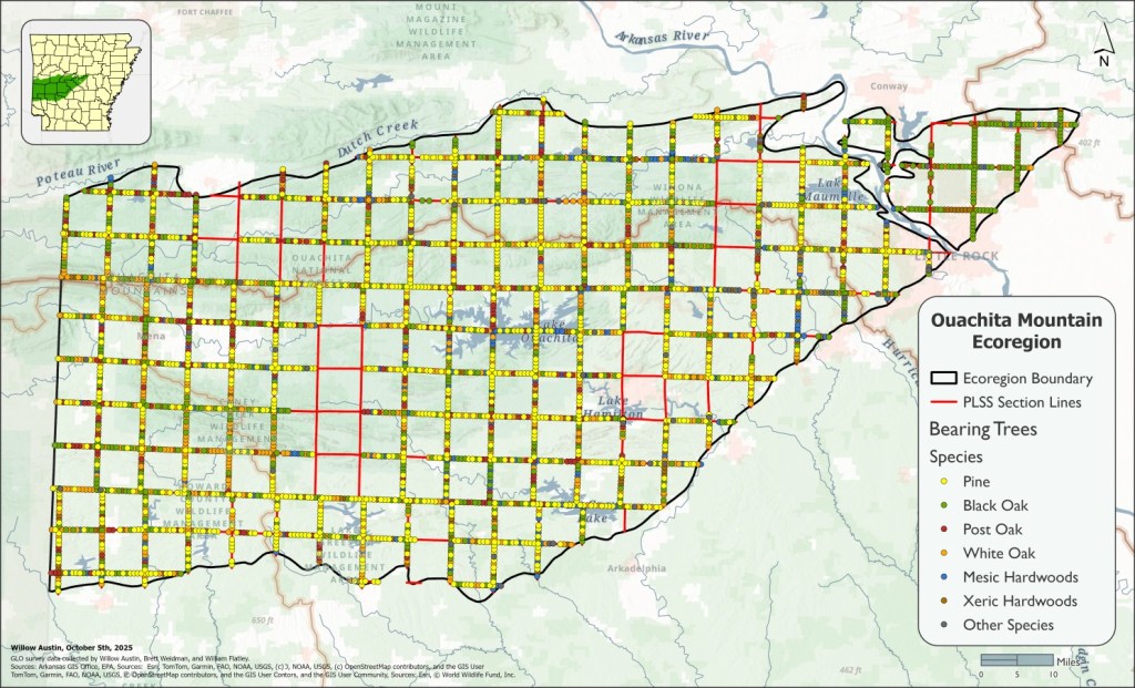
The full distribution of bearing trees is amazing to look at, with shortleaf pine (Pinus echinata) and white oak (Quercus alba) dominating a landscape likely experiencing frequent fire (Foti & Glenn, 1991). A distinct shift in tree species composition can be seen as you cross the Arkansas River into Round Mountain just south of Conway and the area in the modern day Camp Robinson WMA. Pine is replaced by Black Oak (Quercus velutina), representing what I suspect is a fire shadow. The Arkansas River would have functioned as a barrier to fires spreading down the east-west ridges of the Ouachitas.
Also of note are the gaps in the data. You’ll notice that there are townships with no bearing trees recorded. This isn’t from a lack of trying. We digitized the transcribed GLO survey records hosted on the Arkansas GIS Office’s GLO Map 2.3 for the townships intersecting with the OME. These missing sections had survey PDFs linked, but when digitized they only covered surrounding areas.
I believe the missing records could be explained by a lack of transcribed copies for these areas. The original survey notes were handwritten by the deputy surveyors in the early 1800s. These records would then be kept in the regional GLO office and later be entrusted to the state of Arkansas for preservation (Bragg, 2004). They were then transcribed by women working for the Civilian Conservation Corps in the 1930s. There would be over a hundred years between the surveys’ creation and their transcription, plenty of time for pages to be damaged or go missing. As we progress with this research, it would be interesting to delve into the state archives to see if the original notes for these areas still exist, and if they do, create transcribed copies to fill the gaps in the GLO Map data. I will definitely have my work cut out for me reading centuries old cursive, though.
If you’re interested in this research, check out the poster Will presented at the Shortleaf Pine Symposium this year and my graduate thesis research on my profile (under projects).
Eventually, I’d be interested in seeing this data in an interactive web map format for public data exploration. I’d also be interested in applying it in a contiguous model of pre-settlement tree species composition, density, and basal area. Stay tuned for further progress!
References
Bragg, D. C. (2004). General Land Office Surveys as a Source for Arkansas History, The Example of Ashley County. The Arkansas Historical Quarterly, 63(2), 166-184.
Foti, T. L. & Glenn, S. M. (1991). The Ouachita Mountain landscape at the time of settlement. 49-65. Proceedings of the conference on restoration of old-growth forests in the interior highlands of Arkansas and Oklahoma Arkansas, USA Ouachita National Forest and Winrock International Institute for Agricultural Development.


Leave a comment